Will it be a sea breeze day? Matthew Sheahan explains how the 'quadrant theory' can decode likely scenarios on a Solent summer's day
Clear skies at dawn and a hint of wispy cumulus rising above the mainland shore are early signs of a Solent sea breeze day. But where many other venues will gradually wind themselves up into a steady onshore breeze as the land heats up and sucks in the air, the Solent is far more complicated.
Working out if a sea breeze will develop later on in the day during events like Cowes Week is not always straightforward, but renowned meteorologist David Houghton’s ‘quadrant theory’ can help predictions.
Surrounded by land, flat to the north, high to the south and with plenty of twists and turns along a coastline of small rivers and wide bays, the Solent has topographical features that influence both the gradient wind and the development of a sea breeze.
Being able to identify early signs places you in the enviable position of being able to anticipate what happens next, handing you one of the biggest advantages the Solent can offer, inside knowledge on the weather.
Using Houghton’s original data, we summarise six of the most popular Solent scenarios.
Breakfast time with a north-westerly
Running down Southampton Water and off towards the eastern Solent, you will find a band of wind about one force stronger owing to the coastal convergence along the west shore of Southampton Water.
This band extends downwind through the east Solent, across the Ryde Bank and out into the Channel past the Nab tower.
The west Solent is a slightly more complicated picture. Wind bands about 10-15 per cent stronger than the prevailing wind will be blowing out of both the Lymington and Beaulieu rivers. The wind will also veer around 10-15º as it blows off the mainland shore.
Finally, there is a similar effect on the south side of the Isle of Wight with the wind again veering by up to 15º as it rolls of the shoreline.
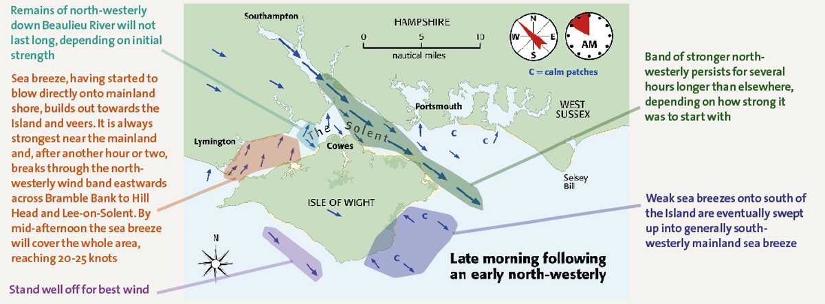
Late morning following an early north-westerly
The band of stronger north-westerly wind coming out of Southampton Water persists for several hours longer than elsewhere – depending on how strong it was to start with.
The remains of the north-westerly down Beaulieu River will not last long – though again this will depend on the initial strength of the wind.
The sea breeze at the western end of the Solent will start to blow directly onto the mainland shore. This breeze builds out towards the island and veers. It is always strongest near the mainland and, after another hour or two, breaks through the north-westerly wind band eastwards across Bramble Bank to Hill Head and Lee-on-Solent. By mid-afternoon the sea breeze will cover the whole area reaching 20-25 Knots.
Stand well off the south-west shore of the Isle of Wight for the best wind. To the south west of the island, you will find weak sea breezes onto the south of the island, which are eventually swept up into generally south-westerly mainland sea breeze.
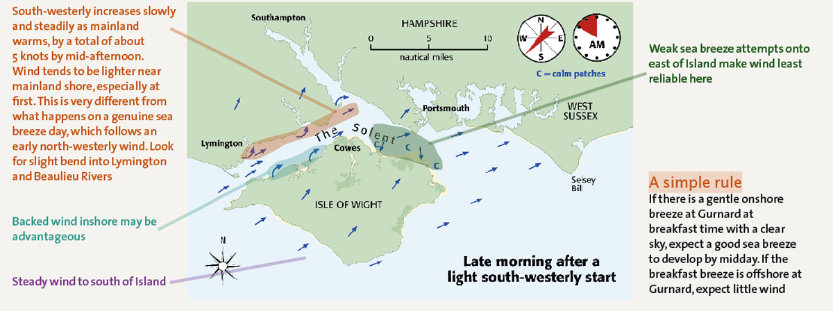
Late morning after a light south-westerly start
In the western Solent, the south-westerly sea breeze increases slowly and steadily as the mainland warms, by a total of about 5 knots by mid-afternoon.
The wind tends to be lighter near the mainland shore, however. This is very different from what happens on a genuine sea breeze day, which follows an early north-westerly wind. Look for a slight bend into Lymington and Beaulieu rivers.
On the north-western shore of the Isle of Wight there is a backed wind inshore which can be advantageous in some situations.
Over in the east Solent the situation can be much more complicated with the weak sea breeze attempts onto the east of the island least reliable here.
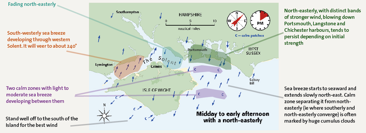
Midday to early afternoon with a north-easterly
In the west Solent, the south-westerly sea breeze will develop and is likely to veer to about 240º.
Further east, to the east of Cowes, there could well be a north-easterly still holding. East further still, off Portsmouth on the mainland shore there is likely to be a north-easterly with distinct bands of stronger wind blowing down Portsmouth, Langstone and Chichester harbours. This tends to persist depending on strength.
Further offshore, out to the east, the sea breeze starts to seaward and will extend slowly north eaast. There will typically be a clam zone separating it from the north easterly off Portsmouth as the two winds converge. This is often marked by huge cumulus clouds.
Late morning after a light to moderate south-easterly start
The best wind to be found in the Solent in this situation is usually near the mainland shore. But the wind will drop generally by about 5 knots during the course of the day as the mainland warms.
The Isle of Wight shorline in the Solent can see the wind become fitful with calms. There will often be weak and temporary sea breeze attempts wherever the initial wind is blowing offshore.
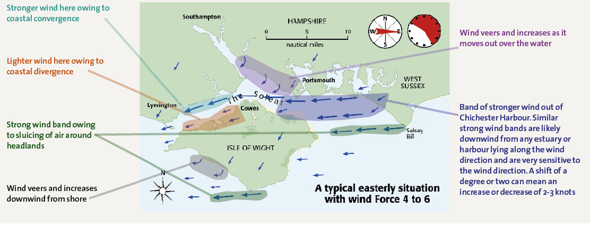
A typical easterly situation with wind Force 4-6
With the wind blowing directly down the Solent, much of the effects in the west are due to coastal convergence and divergence. You will also see the sluicing of air around headlands providing strong wind bands.
At the bottom of Southampton water, you will often find the wind veer and increase as it moves out over the water.
In the central eastern Solent you will find bands of stronger wind coming out of Chichester Harbour. You can also find similar strong wind bands downwind from the many other estuaries in the area or harbours lying along the wind direction. These are all very sensitive to wind direction, however. A shift of a degree or two can mean an increase or decrease of 2-3 knots.
 If you enjoyed this….
Yachting World is the world’s leading magazine for bluewater cruisers and offshore sailors. Every month we have inspirational adventures and practical features to help you realise your sailing dreams.Build your knowledge with a subscription delivered to your door. See our latest offers and save at least 30% off the cover price.


