I've tested useful and not so useful apps for going afloat. Read my reviews here
If you’ve got an iPhone you’ve probably wondered which sailing apps are actually useful and whether they were worth paying for. Here’s a rundown of what I’ve used and tested:
Navionics charts (from £5.99)
The Navionics charting software is the sort of application that justifies having an iPhone all by itself.
First, a few important caveats: the iPhone battery lasts, on average, for about 2 hours’ continuous use, so you’d soon need to recharge (or keep plugged in) and the GPS can be inaccurate if you are using it down below or under cover.
But never mind that. The Navionics charts are brilliantly handy and so keenly priced I can’t think of a single good reason not to buy them.
You can have on tap every chart for the UK and Holland just £14.99. Others regions are even cheaper: £6.99 gets you charting for the Mediterranean and £5.99 the Caribbean and Central America, for example. All these would use a small fraction of the memory on a 16GB iPhone.
There’s no way you would sensibly use it as a primary navigation tool but as a planning device to fiddle around with on the train, office or at home, or use when crewing on someone else’s boat or on a charter, these are fantastic.
The charts are full featured and, like the standard version, you can access detailed tidal information by clicking on the diamonds. The screen refreshes and rescales quickly. Entering waypoints and measuring distance from a given point or mark is incredibly easy and you can make 99 routes and email or store them.
The usefulness of the waypoints is compromised by the lack of VMG, COG and SOG information, but as updates are made regularly, hopefully they will be added in future.
More harbour and port information would be on my wishlist as well.
For the money, though, this is a superb use of everyday technology. Highly recommended.
Met Office Weather (Free)

A brillant and free weather app for the UK – top marks to the Met Office. This is an excellent little app, with great graphics. Finds your location, gives you a 5-day forecast, breakdown in three-hourly segments, wind speed in knots as well as an infrared satellite image of the UK and a rain radar – yay!
Outside the UK, I use Fizz Weather (£2.39). That covers worldwide locations, but I find the graphics sometimes contradict the overview, which is confusing, and overall I’m not convinced about the accuracy of forecasts.
Marine Tides Planner Plus (£4.99)

Tidal information for a vast range of primary and secondary ports. Nice interface, with tidal curves, height and times of HW and LW, rate of fall and a scrolling bar that makes it easy to see exactly what time you’ll have sufficient water to enter or leave.
Aye Tides (£5.99)
Another handy tide time and height calculator for worldwide ports. A bit short of secondary port information in the UK and at £1 more than the Marine Tides app and less attractive graphics I’d plump for the cheaper version.
Sailmaster (£6.99)
Digital compass, heading, countdown timer and boat speed: Sailmaster is designed to act like a dashboard when you’re racing. Fun on the rail.
It’s black and grey display is dull looking, though, and entering waypoints by lat and long co-ordinates is old-fashioned and prone to fat finger errors.
Since it operates (like all these apps) in the foreground you can’t run charting software simultaneously.
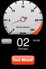
Wind Meter (£0.59)

Nice little app and good value for money. I wouldn’t swear by its accuracy but for a there-or-thereabouts guide it’s fine. A nice gauge-style interface
Marine Rules & Signals (£3.99)
Handy guide to collision regulations, shapes and lights with an attractive interface and very nicely illustrated. It’s a clever move by pilot book publishers Imray but frankly out of whack with the general pricing points of iPhone apps – £3.99 is steep compared with the Navionics charts, not to mention games and other apps.
And to be honest, I’d be a bit old-fashioned here. Collision regs, shapes and lights are really best memorised. What’s the good of fishing around waiting for this app to load if time is running out…?
NOAA Buoy Data Reader (£1.79)
Cheapest of the wind and wave buoy data apps and of debatable value for passage planning as you can get the same information free online on the NOAA website. At a guess probably most useful for surfers.
Feel free to add applications you’d like tested or reviewed, or your comments about using these any other apps right here.
More news and updates on Twitter @elainebunting.com


