
Madeleine and Stephan Strobel describe the sunny world of cruising in Corsica and Sardinia. With medieval architecture, delicious treats, and environmentally protected marine life, it offers a wholesome sailing holiday.
Thinking of cruising in Corsica and Sardinia? Given its strategic position in the heart of the western Mediterranean, it’s hardly surprising that Corsica has been invaded, conquered and colonised many times throughout its long history. But that same accessibility by sea – coupled with the wild, rough beauty of Corsica’s coastline, and the world class beaches and crystalline waters of its southerly neighbour Sardinia – make this region exceptional for cruising.
Island approaches
The islands span the central Mediterranean and are accessible from all directions. The north coast of Corsica is relatively close to the French and Italian Rivieras, whereas southern Sardinia is within easy reach of Sicily and the African coast. The majority of northern European yachts will reach the islands from the French or Spanish coasts and Balearic Islands. The shortest route is from Elba and Capraia in the north, while it’s also possible to cross from Tunisia.

Yachts are drawn to the many islands in the narrow Strait of Bonifacio between Sardinia and Corsica. Photo: Lubos Paukeje/Alamy
Cruising in Corsica
Corsica is a truly unique island. Although it is a ‘territorial collectivity’ of France, it has a proud identity of its own and a strong local independence movement. Nearly half its population lives in the two largest towns of Bastia and Ajaccio, leaving the rest of the island sparsely populated.
The west coast of Corsica is indented and rocky, with magnificent headlands and attractive bays lined with sandy beaches. Parts of the coast are inaccessible by road, like the Désert des Agriates in the north, a totally uninhabited stretch of unspoilt coastline. The exposed anchorages in these areas are excellent daytime stops, though moving to a more sheltered area for the night is recommended.
A spectacular part of the west coast to explore on a calm day is the Scandola Marine Reserve, part of the wider Parc Naturel Régional de Corse. Here the Corsican coast is wild and bleak, becoming more and more dramatic as you approach the breathtaking Punta Palazzu headland, where bright red cliffs tower over the coastline like cathedrals emerging from the sea.

Madeleine and Stephan Strobel have sailed their trusted Bowman 40 Easy Rider extensively around Corsica and Sardinia. Their new and expanded 5th edition of Corsica and North Sardinia was commissioned by the Royal Cruising Club Pilotage Foundation and published by Imray in 2024.
During the summer months, many day boats from Calvi and Girolata criss-cross between the cliffs and the headland. One of the most beautiful coves in this reserve is Marine d’Elbo, surrounded by red rock formations, lush green hills and a Genoese tower. Girolata is the only secure cove in the area and therefore gets very crowded in July and August.
Further south, the coastline between Propriano and Bonifacio, although extremely rocky, offers exquisite anchorages, with white sand and clear turquoise water between the boulders. One of our absolute favourite spots for cruising in Corsica is Cala di Roccapina (41º29’.5N 08º54’.7E): a very difficult to reach cove on a bumpy dirt road which is therefore unregulated and wild.
There are no parasols or restaurants on the beach, no cordoned off swimming area and no lifeguards. Once you have negotiated the boulders in the middle of the cove, you can anchor as close to the beach as you like and dive into the turquoise water.

Alghero old town in Sardinia during a maestrale. Photo: Madeline & Stephan Strobel
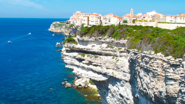
Bonifacio is one of Corsica’s most spectacular attractions. Enclosed within the chalk cliffs which run between Cap de Feno and Cap Pertusato it sits on a narrow, deep inlet lined by near-vertical slopes of white rock, crowned by a medieval walled town and citadel.
The quay is lined with delightful shady restaurants, where we’ve enjoyed many evenings watching boats and superyachts manoeuvring in the harbour. Bonifacio is also a handy place to change crew or welcome guests – there is a nearby airport at Figari, and connecting ferry services.
Article continues below…

Mediterranean sailing: Weather tips from Gibraltar to Turkey
Distances in the Mediterranean can be deceptive, with the distance from Gibraltar to Turkey being close to double that of…

10 destinations that you should put on your cruising bucket list
Jimmy Cornell can safely be described as the father of modern ocean cruising. He founded the ARC rally in 1986,…
Bouches de Bonifacio
The islands of Corsica and Sardinia are separated by the narrow Strait of Bonifacio (Bouches de Bonifacio). Many islands and reefs lie within the strait, with Îles Lavezzi and Île Cavallo on the Corsican side and the Arcipelago di La Maddalena on the Sardinian side (both Lavezzi and Maddalena are marine reserves).
The passage between Lavezzi (Corsica) and Razzoli (Sardinia) is only 3.5 miles wide, and we’ve spent a lot of time criss-crossing between the two as it’s home to some of our favourite spots.

Buoys have been laid in popular Corsican and Sardinian Marine Reserve bays to prevent anchoring and wardens employed to collect fees
There is a fabulous anchorage on Lavezzi (Cala Lazarina 41º20’.3N 9º15’.1E) hidden behind many visible rocks, but open to the south. It is one of the main attractions for day trip boats coming from Bonifacio and a perfect place to swim and snorkel. On shore pay a visit to one of the two cemeteries for the victims of the Sémillante shipwreck of 1855.
The bay can become uncomfortable in some wind directions – the best solution is to move to another anchorage in the Archipelago di La Maddalena, for example Porto di Madonna (41º17’.4N 09º21’.6E), which is protected from all winds apart from the west, or one of our favourite anchorages, Cala Lunga (41º17.8N 09º20’.5) – both in the northern group of islands (Razzoli, Budelli and Santa Maria).
Cala Lunga doesn’t have a beach, but has the most stunning rock formations. It is also much quieter during July and August. Porto di Madonna, which is magical out of season and during the shoulder season (until the end of June) becomes unbearably busy in high season. This is due to the Passo Secca di Morto, a very shallow reef where you are only allowed to swim, snorkel and row with a dinghy. The clear blue water is stunningly beautiful, but becomes a crowded swimming pool in August.
Sardinia
Sardinian history is as convoluted as that of its neighbour, having been a Roman province before being variously ravaged by Vandals, Ostrogoths, Byzantines and Saracens, later ruled by Spain before finally becoming Italian.

Port de Girolata on the west coast of Corsica. Photo: Madeline & Stephan Strobel
Alghero is a medieval walled town made up of Spanish-style Gothic buildings set amid groves of olive and parasol pine trees. The old town is a charming warren of narrow streets beneath turreted ramparts dominated by the Gothic-style duomo and its octagonal campanile bell tower.
Sailing along Sardinia’s north-western coast from Alghero, we found it beautiful yet exposed, and somewhat inhospitable, at the mercy of wind and waves travelling long distances across the western Mediterranean. Apart from a few safe harbours, it offers little shelter in bad weather. In contrast, the north coast is very indented with many bays with superb anchorages and beaches.
Sardinia’s famous Arcipelago di la Maddalena lies to the north/north east of the island. The red granite islands are almost bare of vegetation, except for low, aromatic Mediterranean shrubs, which in spring give off a characteristic scent that can be detected for some distance offshore.

Stephan Strobel enjoying gelato. Photo: Madeline & Stephan Strobel
The mainland Sardinian coast is so close to the Arcipelago di La Maddalena that it can provide plenty of alternative anchorages if the Maddalena islands are too crowded. We’ve resorted to anchoring in Porto Liscia, Isuledda Gabbiani (41º11’.7N 09º19’E) – a paradise for kitesurfers and windsurfers – or the even more sheltered Porto Puddu (41º11’.3N 09º20’E).
Although Sardinia is known for the Costa Smeralda on the north-east coast, developed by the Aga Khan in the 1960s and home to world-famous regattas, it isn’t the most attractive area we’ve visited. The famous Porto Cervo and Porto Rotondo are dead out of season (until the end of June), with shops and restaurants closed and facilities limited. The high-life becomes more and more exclusive during July and August, and mooring fees – if you can get one – are extremely high, while Porto Cervo can be dominated by superyachts provisioning and fuelling.
Go remote
Despite the thousands of visitors to Corsica and Sardinia, the islands remain wild and rugged. If going ashore, exploring the remote, uninhabited mountain areas by car – for example, the windy, very narrow coastal road from Calvi to Cargèse – is a nail-biting, unforgettable experience. Cap Corse has a beautiful coastal path between Macinaggio and Centuri called Le Sentier des Douaniers, and other wonderful hikes are along the Désert des Agriates, where you’ll not see a house, a road or a car for 30 miles.
Weather and winds
The coasts of Corsica and Sardinia have quite distinct weather patterns. The far north of Corsica, Cap Corse, is influenced by the Ligurian sea and northerly winds (tramontana), blowing from northern Italy. The western side of the islands is dominated by prevailing westerly winds (maestrale from the north-west, the ponente from the west and the libeccio from the south-west).

View over the Cala di Volpe, Sardinia. Photo: Madeline & Stephan Strobel
The Bonifacio Strait has its own particular weather system created by the funnelling effect between the two islands where the dominant winds are levante (from the east)
and ponente (from the west).
The east coasts are under the influence of the Tyrrhenian Sea and share a more benign weather than the west coasts. Corsica is partially sheltered from the east by mainland Italy and nearby islands like Elba and Capraia. The dominant winds are grecale (from the north-east), levante (from the east) and scirocco (from the south and south-east).
Radio weather forecasts usually use the quadrantal system for wind direction. The first quadrant (I) covers winds in the 90° quadrant from north to east, with quadrants II, III and IV continuing clockwise.
Thunderstorms are prevalent in the summer. These normally take place near the coast or over the nearby mountains and can be absolutely spectacular. Winds can increase from nothing to Force 5-6 in minutes and blow all around the compass, which makes for excitement in crowded anchorages. One consolation is that they are usually short lived.
 If you enjoyed this….
Yachting World is the world’s leading magazine for bluewater cruisers and offshore sailors. Every month we have inspirational adventures and practical features to help you realise your sailing dreams.Build your knowledge with a subscription delivered to your door. See our latest offers and save at least 30% off the cover price.