Chris Tibbs outlines the tactical challenges on a run across the Atlantic to St Lucia.
The ARC fleet leaves the Canary Islands at the end of November to arrive in the Caribbean after the hurricane season has ended and also to be able to get a full season of cruising before the start of the next one. Hurricane season runs from June to November although tropical storms can develop outside these dates.
Weather
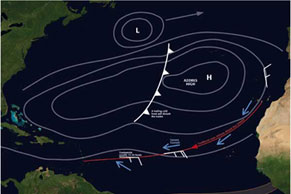
The tradewinds are driven by the position and intensity of the Azores High. This varies year on year and some years it is downwind the whole way across with yachts claiming a spinnaker run from start to finish. An exception rather than the rule and there is a great deal of inter-annual variability. November may be the most convenient time to cross, but it is not the most settled time of year to leave the Canaries and some years there may be a few days of headwinds before the tradewinds become settled.
Research is currently underway with regard to something known as the North Atlantic Oscillation which links sea surface temperature earlier in the year with the expected intensity of the Azores High and the Icelandic low. This gives a long-term forecast on how intense the Azores High will be and therefore how strong and settled the tradewinds are likely to be.
The real reason for the interest in the NAO is for a prediction on whether the winter will be mild, wet and stormy or cold and dry over north-west Europe. There is a good correlation between the prediction and the outcome.Although this is of no use for daily forecasts, it does give a trend which goes some way to explaining the difference between a low-wind year when the trades may be 13-18 knots and a strong year when they may be 23-28 knots.
In most years there is a region south of the Azores High that produces a good 18-23 knots, but it may take a dive south to the latitude of St Lucia to find it.
Mid-Atlantic trough
We think of the Azores High as a permanent area of high pressure and most years it is. Depressions can end up to the south-east of the High, which will give headwinds for the first day or so and the necessity to get further south than usual to get into the trades. The Azores High is often divided by a cold front – or the remains of a cold front that penetrates into the High.
This gives a mid-Atlantic trough with light variable wind. Sometimes it necessitates getting south of the latitude of St Lucia to avoid getting held up while yachts to the north may have a day or so of headwinds before the trades are found again. Many cruising yachts will use their engines to get through the trough and the light variable wind on the west side.
Wind angles
Wind angles are all important and the further south you get, the more easterly the wind will be, so it can be good to get some westing early on starboard gybe while the wind is north-easterly before gybing to the south as the wind lifts you and becomes easterly. The danger is getting west too early and into the Azores High – as with most things in sailing it is a compromise and will depend on sails carried, the yacht’s displacement and the experience of the crew. There is no easy answer. For a straightforward crossing head south, but you are unlikely to be first into St Lucia.
Squalls
Squalls will become more common the further along the route you progress and they may become organised, as in a tropical wave and sometimes, like last year, the squalls become widespread and intense with galeforce gusts as the squalls hit. In extreme cases there have been reports of 50+ knot squalls. Squalls vary year on year, but most boats will encounter a few.
Tracking a squall
As squalls travel in the direction of wind higher up in the atmosphere, they do not exactly follow the surface wind. As a rule the squalls will come from a direction veered to the surface wind. Track them on radar or by using a hand-bearing compass.
This implies that on a port gybe you will cross the track of the squall faster than on starboard, where your track and the squall’s track are likely to be similar. If the clouds are fast moving, raining and reach high into the sky, the gust front arrives with the rain and it will be strong – possibly to galeforce.
Route
“Go south until the butter melts then turn west,” or follow the rhumb line? Historically sailing ships would head south, almost to the Cape Verde Islands before heading west. Latitude was easy to measure, but longitude needed accurate time, so getting to the correct latitude then running the longitude down was an accepted method of navigation that also took advantage of the tradewinds.
For a modern yacht, with good performance and good weather forecasting, considerable gains can be made by cutting the corner. On some years this is considerably faster, other years the traditional route is the best. It all depends how well established the Azores High is and if there are any cells of low pressure in the Atlantic.


